Irrigated areas cuantification by remote sensing
Monday, September 26, 2016
SM Geodim has won the tender of the service: “Delimitation through remote sensing of crop surfaces in the irrigated areas of Central and Ardila subsystems’ of the Guadiana River Basin”.
In 1987, the Ministry of Public Works and Urbanism was raised the problem of knowing the groundwater extractions, intended to irrigation, in the aquifers of La Mancha (Eastern and Western). It was necessary to quantify the necessary extractions that could justify the drastic decline occurring at the exits to the Júcar River in its middle course, or the drying of the Guadiana in the vicinity of the Tablas de Daimiel.
For the first time, in our country and in Europe, satellite remote sensing was being used for applied in hydrology and water uses. The methodology, results and suggestions of that study were published by Salomón Montesinos, in Bulletin nº 51 of Information and Studies of the Geological Survey Directorate General of Hydraulic Works.
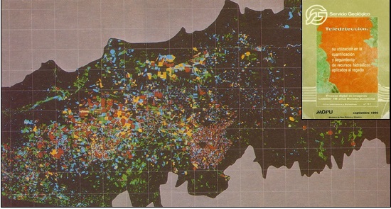 Quantification by remote sensing of the existing irrigated surface in 1987 in the aquifer 23. At the top right of the image, cover of the bulletin of SGOP.
In the Guadiana basin, in the late eighties, the plight reached in the aquifers of the Llanura Manchega forced in February 1987, the provisional declaration of overexploitation of the aquifer of La Mancha Occidental and, in April 1988, by a Royal Decree, the aquifer of Campo de Montiel was provisionally declared overexploited.
During the early years, the monitoring of exploitation control was made from aerial color photographs and field campaigns which used as reference document these aerial photographs.
Since 1997, remote sensing techniques are being used for the estimation of the extracted volume, both in all the aquifers and in each registered exploitations of irrigation.
Also in 1997, in order to, internationally, validate the proposed methodology in the Guadiana basin, it was presented at the R & D Framework Programme of the European Union, the ASTIMwR project (Application of Space Techniques to the Integrated Management of river basin Water resources, 1997-1999), the first European project using space remote sensing in the planning and management of water resources in a river basin area.
Nowadays, our methodology is currently and successfully used in the Spanish river basins in which an objective geo-referenced information about the irrigated area, potentially irrigated area or at irrigation is necessary.
The assessment of the water demand evolution over time is one of the aspects that produce larger deviations and errors in the usual process of restoring of the natural regime.
The study of the agricultural demand evolution is one of the most significant aspects, due not only to the specific position representing the global demand of a basin, but also the difficulty of its estimation by conventional techniques. In Spain, agricultural demand accounts for about 85% of the total demand.